

Have you ever wondered how planes, that are at such high speeds even during landing, land in adverse weather conditions where the visibility is so low that a pilot would not be able to see more than a few hundred feet? The aircraft relies on certain systems known as Instrument Landing Systems, that are available at the airport.
An instrument landing system (ILS) is a precision radio navigation system that provides short-range guidance to aircraft to allow them to approach a runway at night or in bad weather.
Let us dig in a little deeper into what the Instrument Landing Systems are and how they help the aircraft to land safely in adverse conditions, where the visibility is too low for the pilots to visually see the runway and make a safe landing.
Introduction of the Instrument Landing Systems
The ILS was developed in the 1920s and 1930s, and became widely used during World War II, especially by the US and UK forces. It was adopted as the international standard for precision approaches by the International Civil Aviation Organization (ICAO) in 1947.
Since then, it has been improved and refined, and different categories of ILS have been defined to allow lower decision heights and runway visual ranges depending on the equipment and qualifications of both the aircraft and the airport.
The ILS is still a widespread and reliable system for landing in poor visibility conditions, although newer technologies such as global navigation satellite systems (GNSS) are gradually replacing it.
How does an Instrument Landing System (ILS) work?
ILS consists of two directional radio signals, the localizer and the glideslope, that together provide pilots with both horizontal and vertical guidance respectively, during the landing approach.
In order to guide the aircraft during landing, the pilot relies on signals displayed on an instrument, often accompanied by additional pointers on the attitude indicator. The goal is to keep these indicators centered as the aircraft approaches the runway, reaching the decision height.
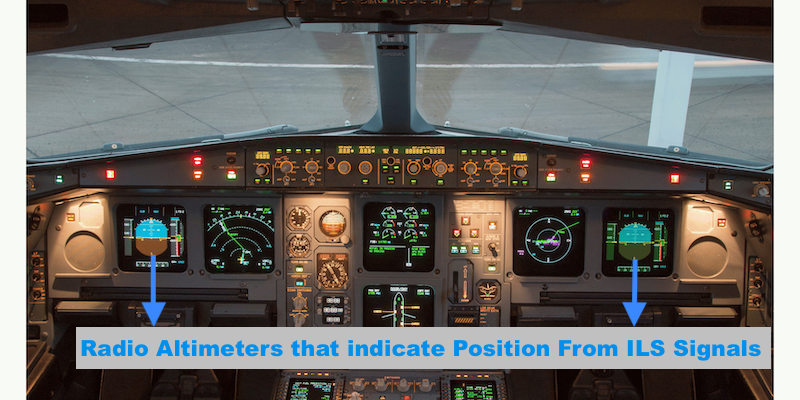
This height represents the minimum altitude at which the pilot must spot the runway or decide to abort the landing. It’s a critical moment that requires precision and focus from the pilot.
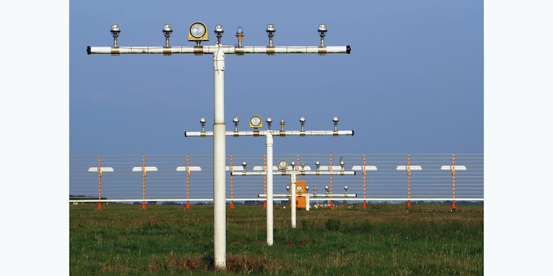
The ILS usually includes high-intensity lighting at the end of the runways to help the pilot locate the runway and transition from the approach to a visual landing
What are the components of an Instrument Landing Systems?
The ILS consists of four main components: the localizer, the glideslope, the marker beacons, and the runway lighting.
Localizer
The localizer is a radio transmitter that emits two narrow intersecting beams, one slightly to the right of the runway centerline, and one slightly to the left. The beams are modulated with different frequencies, 90 Hz for the right beam and 150 Hz for the left beam. The receiver on board the aircraft detects both frequencies and compares their strength.
If both frequencies are equal, it means that the aircraft is on the centerline of the runway. If one frequency is stronger than the other, it means that the aircraft is off-center, and needs to correct its course accordingly.
The localizer provides azimuth guidance, or lateral deviation from the centerline, up to 18 nautical miles (NM) from the antenna, which is usually located at the opposite end of the runway from where the aircraft lands.
Glideslope
The glideslope is another radio transmitter that emits two narrow intersecting beams, one slightly below the required vertical profile, and one slightly above it. The beams are also modulated with different frequencies, 90 Hz for the lower beam and 150 Hz for the upper beam. The receiver on board the aircraft detects both frequencies and compares their strength.
If both frequencies are equal, it means that the aircraft is on the correct vertical descent profile. If one frequency is stronger than the other, it means that the aircraft is too high or too low, and needs to adjust its altitude accordingly.
The glideslope provides elevation guidance, or vertical deviation from the desired glide path, up to 10 NM from the antenna, which is usually located on the side of the runway, about 1,000 feet from the threshold.
Marker beacons
Marker beacons are radio transmitters that emit a distinctive tone or Morse code when an aircraft passes over them. They are used to provide distance information as the approach proceeds. There are three types of marker beacons: outer marker (OM), middle marker (MM), and inner marker (IM).
The OM is located about 5 NM from touch-down, and indicates that the aircraft has intercepted the localizer beam. The MM is located about 1 NM from touch-down, and indicates that the aircraft has reached the decision height for a Category I approach. The IM is located near the runway threshold, and indicates that the aircraft has reached the decision height for a Category II or III approach.
Not all ILS approaches have all three marker beacons, and some may use distance measuring equipment (DME) instead.
Runway lighting
Runway lighting consists of high-intensity lights that help the pilot locate the runway and transition from the instrument approach to a visual landing. There are different types of runway lighting, such as approach lighting system (ALS), runway end identifier lights (REIL), runway edge lights (REL), runway centerline lights (RCL), and touchdown zone lights (TDZ).
The ALS is a series of lights that extend from the runway threshold to about 2,400 feet or more along the centerline. The ALS provides visual cues for the alignment and distance of the runway. The REIL are two flashing white lights that identify the runway end. The REL are white lights that outline the runway edges. The RCL are white lights that mark the runway centerline. The TDZ are white lights that indicate the touchdown zone of the runway.
What are the different categories of ILS?
The ILS is classified into different categories according to the minimum decision height and runway visual range required for the approach. The lower the category, the more precise and reliable the equipment and the pilot must be. The categories are:
- Category I (CAT I): The decision height is not lower than 200 feet (60 m) above the runway threshold elevation, and the runway visual range is not less than 550 m (1,800 ft).
- Category II (CAT II): The decision height is not lower than 100 feet (30 m) above the runway threshold elevation, and the runway visual range is not less than 300 m (1,000 ft).
- Category III (CAT III): There are three subcategories of CAT III, depending on the decision height and the runway visual range:
- CAT IIIa: The decision height is not lower than 50 feet (15 m) above the runway threshold elevation, and the runway visual range is not less than 175 m (575 ft).
- CAT IIIb: The decision height is lower than 50 feet (15 m) above the runway threshold elevation, or no decision height is used, and the runway visual range is not less than 50 m (165 ft).
- CAT IIIc: No decision height or runway visual range limitations.
Can an autopilot land an aircraft without Instrument Landing Systems at an airport?
No, an autopilot cannot land an aircraft without Instrument Landing Systems (ILS) at an airport. The ILS is a critical component that provides accurate and reliable guidance for landing, especially in adverse weather conditions or low visibility situations.
In the absence of ILS, the autopilot won’t be able to determine the aircraft’s height above the ground accurately or maintain the correct lateral control during landing. Thus, without ILS, pilots have to rely on other navigation aids, or more likely, manual control to land the aircraft. It underscores the need for airports to equip with certified and calibrated ILS for facilitating autopilot-assisted landings.
But, it is important to note that autopilot can still be engaged at airports without ILS. This allows pilots to use the autopilot to fly the aircraft from cruising altitude all the way down to a certain altitude close to the ground before they take over manual control and complete the landing procedure. Thus, even without ILS, an autopilot can make flight operations faster, safer and smoother.
If you would like to know about autopilots in aircrafts check this post.
Some other frequently asked questions about Instrument Landing Systems:
Do pilots always use ILS to land?
No, pilots do not always use the Instrument Landing System (ILS) to land. Though ILS provides crucial assistance during poor weather conditions or at night, it isn’t always necessary. In clear weather conditions, pilots often opt for a visual approach, relying solely on their eyesight and visual references on the ground.
Additionally, not all airports are equipped with ILS, necessitating the use of other navigation aids or GPS-based systems for approaches and landings. However, even when ILS isn’t used for landing, pilots regularly train on it to maintain their proficiency.
Does every airport have ILS?
No, not every airport is equipped with an Instrument Landing System (ILS). The presence of ILS is largely dependent on the airport’s size, location, and volume of traffic. Major international airports and those located in areas prone to adverse weather conditions typically have ILS to facilitate safe landings.
Smaller airports, particularly those in regions with generally clear weather, often operate without ILS, utilizing other navigational aids or visual references for landing. It’s important to note, however, that even without ILS, stringent safety procedures and protocols are in place to ensure safe landings at all times.
Do airlines use ILS or RNAV?
Airlines may use either ILS or RNAV depending on several factors, such as:
- The availability of ILS or RNAV equipment at the airport and on board the aircraft. Not all airports have ILS facilities, especially in remote or less developed areas. Similarly, not all aircraft have RNAV capabilities, especially older models.
- The requirements of the airport and the airspace. Some airports may have mandatory or preferred ILS or RNAV procedures for certain runways or traffic conditions. Some airspace may also have minimum RNAV or RNP specifications for certain routes or altitudes.
- The preferences of the pilot or the airline. Some pilots may prefer ILS over RNAV because they are more familiar with it or they trust it more. Some airlines may prefer RNAV over ILS because they can save fuel and time by using more direct routes.
In summary, airlines use both ILS and RNAV depending on various factors, such as availability, requirements, and preferences. Both systems have their pros and cons, and they serve different purposes in helping aircraft land safely and accurately.